Growing Farmers

Suraj Budathoki

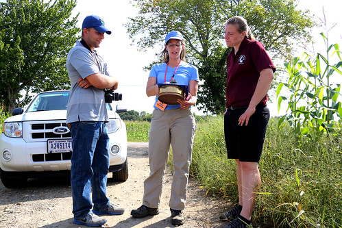
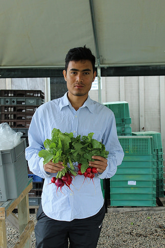
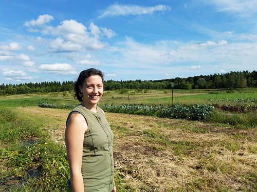
Suraj Budathoki grew up farming next to a Bhutanese refugee camp. MFA’s Farmer Training Program helped him to pursue his passion for sustainable farming in MN. Photo by Laura Hedeen, employee at Minnesota Food Association.

Fresh. Local. Honest. This motto underscores the guiding philosophy of the Minnesota Food Association (MFA). To achieve its goals of promoting healthy food and regenerative agriculture, the MFA offers workshops for farmers and helps immigrants learn how to farm sustainably in local conditions.

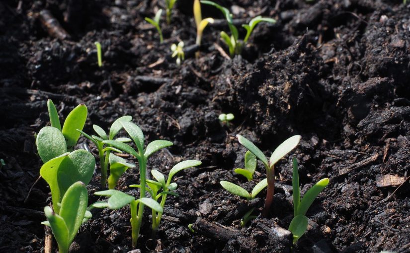
The MFA manages Big River Farms, a 150-acre certified-organic teaching farm. Farmers can enroll in a three-year training program, during which they’re taught about local soils and growing conditions, trained in organic certification and farming methods, and provided a large plot of land to manage. Many of the farmers are immigrants and refugees.

“I thought America was all cities and buildings. I didn’t picture the farmland,” said Suraj Budathoki, a Bhutanese refugee from Nepal. He is a recent graduate of Big River Farms.

Budathoki grew up in a refugee camp. He helped his parents farm a small plot of land just outside the camp. When he immigrated to the United States, he was familiar with farming, but not with Minnesota agriculture. Big River Farms helped him make the transition. “I like nature and working in the environment. It’s my passion.”

“Big River Farms works with immigrants, minorities, veterans and members of the LGBT community,” says Hilary Otey Wold, executive director at MFA. “Reaching out to the historically underserved is a big part of what we do.”

Hilary Otey Wold, Executive Director at Minnesota Food Association

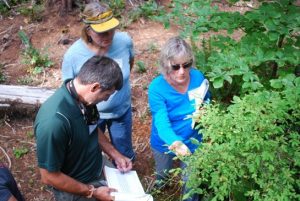
“We’re looking for mutually-beneficial outcomes through sustainable methods,” said Hilary Otey Wold, Executive Director at Minnesota Food Association. Photo by Julie MacSwain, NRCS MN Public Affairs Specialist.

USDA’s Natural Resources Conservation Service supports MFA in its outreach efforts. “We are committed to reaching and helping all farmers who are ready to practice conservation,” said NRCS Chief Jason Weller. Funding provided by NRCS’ Conservation Innovation Grant (CIG) program helps MFA reach, educate, and empower future conservation leaders.

While teaching technical skills, MFA also encourages social skills. “Farmers are teaching farmers,” said Wold. “Experienced farmers mentor those who are new.” The benefits of this mentorship extends beyond the program. “Many of our farmers go on to become active leaders in the community. They’re eager to share skills and knowledge with their neighbors.”

While they’re practicing sustainable, organic farming methods, farmers also learn how to market and sell produce through Community Supported Agriculture (CSAs) and farmers markets. They learn the full farm-to-market procedure.

“I grew up on a farm in rural western Kenya,” said Moses Momanyi, another graduate of Big River Farms. “Everything we ate we grew. The farming lifestyle is in me, it’s in my family.” Momanyi and his family now have their own operation, Dawn 2 Dusk Farm.

His experience with the MFA paved the way for his current success. “MFA has been very an excellent resource,” he said. “They have helped me to know that I can do this. If I hadn’t come to MFA, I couldn’t have figured out how to do wholesale, or the CSA, or farmers markets. It would have been very difficult.”

In addition to helping historically underserved farmers, the MFA offers many public workshops and field days throughout the year. “We want to provide the farming community with the knowledge and training it needs,” said Wold. “Our workshops are very hands-on. We talk about the best farming methods for local conditions.”

The successful, ongoing work by the MFA proves that conservation farmers aren’t born, they’re grown.

Since 2009, USDA has invested more than $29 billion to help producers make conservation improvements, working with as many as 500,000 farmers and ranchers each year to implement conservation practices on a total of 400 million acres of farm, ranch and forestland. Since 2009, over 400 Conservation Innovation Grants have been awarded to support innovative conservation approaches and technologies that develop new ways to attract private investment in natural resource conservation and help farmers and ranchers make their operations more resilient to climate change. For the latest selection of Conservation Innovation Grants, view the 2016 award announcement or to find out more about current and past projects, visit Conservation Innovation Grants on the web. To read more about USDA’s investments in rural America and its successful turnaround, visit USDA’s latest entry on Medium.com, Rural America Is Back in Business.

Moses Momanyi

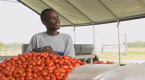
Moses Momanyi knew a lot about farming when he immigrated to America from Kenya, but MFA taught him the logistics of bringing produce to market. Image taken from Minnesota Food Association video.

Alum Proves Every Day that Diversity Programs Grow Agriculture’s Next-Gen Leaders

Victoria LeBeaux

Victoria LeBeaux, national program leader with the National Institute of Food and Agriculture. Photo by Carlos Harris

There is no one-size-fits-all approach to career development and, according to one of the nation’s new leaders in agriculture, the course one steers toward a profession in agriculture can be as varied and diverse as the population itself.

“I’m not a big fan of the term ‘pipeline’ because it implies that there is only one way in and only one direction you can go,” said Dr. Victoria LeBeaux, a national program leader (NPL) with USDA’s National Institute of Food and Agriculture (NIFA).  “If that were true I certainly wouldn’t be here, since I had no intention of studying agriculture.”

As an undergraduate, she studied economics with the goal of working in international development. Prior to starting her doctorate in sustainable agriculture, LeBeaux lived in rural areas in France and Austria and volunteered in Mexico.  Iowa State University ultimately recruited her to complete doctoral training in a three-year NIFA-funded National Needs Fellowship (NNF) program.

NNF trains students for masters and doctoral degrees. In some cases it also provides additional post-doctoral training for the Fellows.  For LeBeaux, that additional training meant a six-month stint in Guatemala where she examined how technical assistance providers helped enhance regional food security by advancing sustainable agriculture practices.

LeBeaux returned to NIFA in 2014 after completing her Ph.D. and subsequent postdoctoral studies, and became an NPL in NIFA’s Division of Community and Education.  In that role she manages about $10 million in federal funding that supports secondary and postsecondary research, education and extension in the food, agricultural, and human sciences. These programs include the Educational Literacy Initiative’s Research and Extension for Undergraduates (REEU) fellowships program.  REEU provides experiential learning opportunities for underrepresented and first-generation college students. In addition, she uses her scientific training to represent NIFA in federal initiatives like USDA’s Know Your Farmer, Know Your Food, which helps coordinate USDA programs to strengthen local and regional food networks nationwide.

“I sincerely appreciate the opportunities provided though the NNF program,” she said.  “As with many other young people, pursuing doctoral education was not on my radar and would not have been possible had I not had the financial support provided by the grant.  I think we need to create a diverse array of pathways to link young people to careers in agriculture and to show them that whatever they are interested in, there are opportunities in agriculture.”

NIFA programs offer grants for K-12 schools and community colleges, such as The Secondary Education, Two-Year Postsecondary Education, and Agriculture in the K-12 Classroom Challenge Grants (SPECA) program; funding for undergraduate and masters level education such as the Higher Education Challenge Grants program and the Multicultural Scholars Program (MSP); and support for doctoral studies is provided by the NNF Fellowship and the Education and Literacy Initiative.

NNF supports 45 new masters and doctoral students each year, while MSP supports 35 undergrads.

Beyond grants, there are many other ways people can benefit from NIFA. For example, educators can access free curriculum from AITC through its Curriculum Matrix. NIFA is also the home of 4-H National Headquarters that supports the positive youth leadership development. NIFA is also a key partner with the Cooperative Extension Service, which operates offices across the country to provide community education in agriculture, health, nutrition, personal finances, and more.

NIFA invests in and advances agricultural research, education and extension and seeks to make transformative discoveries that solve societal challenges.

Massachusetts’ Smarter Lunchrooms Movement

A lunchroom menu board

Lunchroom menu boards used to highlight the “targeted entrée” and promote theme days with creative and descriptive names for the entire reimbursable meal (Georgetown High School).

Through the Team Nutrition initiative, USDA provides grants to state agencies to expand and enhance their training and educational activities to help schools provide appealing and nutritious meals, nutrition education and healthier school environments. These efforts are designed to help children get the nutrition they need to learn, grow and be healthy.  In addition to grants, Team Nutrition provides free nutrition education materials to schools, child care settings and summer meal sites that participate in the Child Nutrition programs.

By Samantha Therrien, graduate student, Framingham State University Food and Nutrition Program & Karen McGrail, MEd, RDN, LDN, Director, the John C. Stalker Institute of Food and Nutrition at Framingham State University

It’s that time again! As students head back to school many school nutrition programs across Massachusetts are continuing to use Smarter Lunchrooms strategies gained through their participation in a USDA Team Nutrition grant. The research-based Smarter Lunchrooms Movement, established at the Cornell Center for Behavioral Economics in Child Nutrition Program, focuses on creating sustainable lunchrooms that make the healthy choice, the easy choice for students. The Movement is based on the idea that even small, low-cost changes can make a big difference, and Massachusetts schools are benefitting from this first-hand.

As part of the USDA Team Nutrition grant, 51 schools across the Commonwealth received technical assistance and professional development delivered by a cadre of three Smarter Lunchrooms coaches. Here is how it worked: The coach completed the Smarter Lunchrooms Scorecard and snapped photos of the cafeteria during lunchtime to establish a baseline. The visit included a brief training session which served not only to educate staff, but to create Smarter Lunchrooms buy-in and garner enthusiasm. Before wrapping up the three-hour visit, the Smarter Lunchrooms coaches assisted the director and/or manager to set an action plan with specific goals, objectives and a practical implementation strategy.

After the visit, ongoing communication between the coach and the school served to provide welcomed technical support and resources. At a return visit later in the school year, the Smarter Lunchrooms scorecard and photos were repeated and the results of the plan assessed. Results were favorable…on average Smarter Lunchrooms scores increased by 30 percent, fruit sales increased by 9 percent and vegetable sales increased by 51 percent.

Take a look at a couple of the low-cost Smarter Lunchroom strategies implemented by schools in Massachusetts.

Massachusetts will sustain the Smarter Lunchrooms Movement this school year based upon the project developed with the USDA Team Nutrition grant.

Signage with vegetable names at Chicopee Public Schools

Signage with creative vegetable names at Chicopee Public Schools.

Getting Serious about Soil Part 1: An Introduction to the Importance of Our Soil

By Lea Sloan, American Forests

This is part one of a three-part series exploring the importance of nutrient-rich and stable soil.

SoilI was fortunate to be invited to participate in a recent day-long seminar at the White House Office of Science and Technology Policy that was focused on the alarming fragility of our soil — an essential foundation for much of life on the planet. An impressive brain-trust of scientists, federal agency representatives, researchers and nonprofit leaders came together to discuss soil as a renewable resource, how to best advance public understanding and inspire action to confront one of the most serious challenges facing our planet today.

I confess that as a tree person, and officially as an American Forests person, there is a bit of a “can’t see the soil for the trees” phenomenon — our focus tends to be mostly above ground, although we are keenly aware that without nutrient-rich and stable soil, trees and forests are not happy. Their growth and prospects for longevity are essentially tied to the soil they grow in, and trees play a critical role in nurturing the biodiversity that creates healthy soil.

But, as I was reminded, soil’s capacity for carbon and nutrient storage echoes the role of trees. Soil filters and stores nutrients and sediment. Seminar participants discussed the fact that the nutrition in our food is directly related to the health of soil, and that our food today is sorely lacking in the nutritional benefits that many people around the world have enjoyed for millennia. Things have changed in the last century since agribusiness began dominating farm management strategies and promoting the use of chemical fertilizers, herbicides and insecticides, largely turning away from practices such as crop rotation, including planting cover crops that are just turned under.

It was not entirely news to me that our soil is actually disappearing, but it is eye-opening to be reminded that soil on cultivated cropland is eroding at an average rate of 5.2 tons per acre per year, while the average rate of soil formation is perhaps literally glacial —  .008 to .51 tons per acre per year.

We often cite the benefits of trees in regulating stormwater, meaning their roots, but without soil, tree roots would, of course, never hold. In the last five decades, experts noted, extreme precipitation events driven by climate change have rapidly increased erosion. One hundred tons of soil can be lost PER ACRE in a torrential storm.

An attention-grabbing press release and National Call to Action issued by the White House after the conference noted that the U.S. is projected to “run out of topsoil — the medium upon which crop production depends — before the end of the 21st century.” The call to action seeks innovative solutions through technology and scientific expertise to develop solutions to protecting soil through measuring, mapping and sharing data — and educating and engaging the American public. American Forests continues to do its part in soil preservation on behalf of our supporters, with more than 50 million trees planted since 1990.

Monitoring a changing climate

Brad Withrow-Robinson, Forestry & Natural Resources Extension agent for Benton, Linn and Polk Counties.

In previous installments of this blog, we have discussed a variety of topics that create challenges for landowners and land managers who are trying to manage their properties in light of climate change, including that we cannot expect just one outcome in any region, but many outcomes according to site-specific factors like elevation, the slope and the direction it faces.

For landowners interested in reducing their risk or increasing a forest’s resiliency, there is still no clear and easy path forward. Not

OST trainees recording life stages of a huckleberry at the HJ Andrews forest. Photo B. Withrow-Robinson

enough is known and we need more information to guide our actions.  Long-term data is the best source of information to shed light on changing weather patterns as well as the response of plants, animals and ecosystems to the changes, including changes in seasonal events and patterns (phenology).   That data and knowledge can come from a number of institutional resources, but it can also come from the public, through citizen science efforts.


Citizen science programs are research collaborations between scientists and community volunteers. Examples include the Audubon Christmas Bird Count, iNaturalist and Monarch Watch. Some common characteristics of citizen science programs include: contributions by many people, often over a large area; standardized protocols defining simple, non-technical data collection procedures; the work helps answer a question of scientific interest and; there is some benefit for participants. Citizen scientists collect and report data about the natural world in their local area, expanding both the opportunities for scientific data collection for researchers and access to scientific information for communities.  These projects have potential to be very effective, especially in gathering data across a large landscape, like Oregon.


Oregon Season Tracker (OST) is just such a project in which trained OST volunteers observe and report data on precipitation and phenology (seasonal events) at their woodland, farm, ranch or home site. OST was created as a joint program of OSU Extension Service and the HJ Andrews research forest to help scientists in Oregon fill data gaps, and expand the scope and inferences of climate research across the state’s diverse landscapes. The project also partners with two national citizen science programs to collect and manage the OST volunteer’s data: the National Phenology Network (NPN)’s Nature’s Notebook; and Community Collaborative Rain Hail & Snow Network (CoCoRaHS).


Mark Schulze, Director of HJ Andrews and OST cofounder explaining some precipitation research instruments at the Andrews.

The idea is to enrich the extensive research in forest ecosystems and responses to climate variability and disturbance already underway at the HJ Andrews Experimental Forest, Long Term Ecological Research (LTER) program.  Teams are studying the weather as well as seasonal patterns among many different species in the complex terrain of the Andrews, located in the western Cascade mountains.  While focused and detailed, information collected at the Andrews and similar research stations represents relatively scattered sites, making it difficult to understand know how broadly their findings apply across the landscape.  Citizen science offers a way to gather related data from a much wider area.  So when Pat monitors and reports on blossoming snowberries at her house in the mid-Willamette Valley, and again at her woodland property miles away in the Coast Range, she is helping develop a data set and a picture of change that is much more representative of the state.

The OST citizen science project is also of great interest to Chris Daly, who is a scientist at the HJ Andrews LTER and director of the PRISM Climate Group at Oregon State University. PRISM (Parameter-elevation Regressions on Independent Slopes Model), is a sophisticated computer model that Chris and colleagues use to estimate weather and climate variables like precipitation and temperature in fine detail across large areas of the landscape.  PRISM makes large global weather models more accurate by predicting how the big patterns (like movement of the jet stream) will affect things at the small, local scale.  This allows weather and climate forecasters to pinpoint  specific predictions for Corvallis, Salem and Pacific City.  Yeah, it is PRISM that is telling you it will be cool and to bring a sweater when going to the Oregon Coast during a Willamette Valley summer heat wave.

Chris Daly maps weather and climate using data collected by OST volunteers, among others. Photo: PRISM

To make its predictions, PRISM needs lots and lots of data from many different and specific landscape situations, which it collects from an array of weather stations at airports or government offices. PRISM also uses the data collected by OST and other CoCoRaHS volunteers who are adding many new data points, often in remote areas that are not well represented in the data.  So each time Sophia reports the daily snowfall on her hillside in Klamath Falls, she is helping improve the understanding and the accuracy of weather and climate forecasts developed by the many government agencies businesses that use PRISM information, especially for areas without many weather stations, as in southern and eastern Oregon.

Since launching OST as a pilot in 2014, the partnership has already over 150 observers and added dozens of new reporting stations in 15 Oregon Counties, and reported tens of thousands of individual observations, many in more rural areas including mountain slopes, and backyard gardens. The OST citizen science program is making a useful contribution to the effort to monitor and understand climate change and its impacts.

What motivates OST volunteers like Sherm to go out each morning, coffee cup in hand, to make the daily precipitation report, or look for budbreak on the vine maple every spring?   They tell us, “I’m interested in being a part of a large research/observation group studying our surroundings” or “Improving my understanding of local climate and variability is the key to improving (my) ability to manage land in the face of climate change.”

Students record plant phenology data to share with HJA researchers. Photo: Jody Einerson

This reflects another benefit of citizen science programs which create new channels of communication between climate researchers and the communities in which the citizen scientists live, farm or ranch, leading to new conversations and understanding. Extension has taken the lead in making that connection in the OST partnership, providing ongoing learning opportunities for volunteers through a website and periodic newsletters, produced by OST Program Coordinator Jody Einerson.  The Observer newsletter features profiles of participating researchers, volunteers and school programs to share their perspectives and experiences, and school kids share their insights in a video exchange with “Researcher Mark” (Schulze) at the Andrews.  Follow this link for more.

Sound interesting? For more information about OST, visit the Oregon Season Tracker website and check out ways to “Become an Observer” on the right hand panel.

Wise management of forest and other natural resources in a changing world requires long term information and fine resolution to guide actions at both local and landscape level. Citizen science projects like Oregon Season Tracker are a constructive way to monitor changes across a large and diverse landscape, build a broad research base widely available to scientists, connect scientists and rural communities and help the natural resource managers – farmers, forest landowners and ranchers, get info they need.

The post Monitoring a changing climate appeared first on Oregon Forests and Climate Change.

Are You and Your Pets Ready in an Emergency?

APHIS employees working with State and Federal partners on an Animal Care Emergency Exercise

Employees with USDA’s Animal and Plant Health Inspection Service’s Animal Care program work with State and Federal partners on an Animal Care Emergency Exercise in Baton Rouge, LA.

We are reminded often throughout the year of the devastating impacts that families and their communities experience when natural disasters such as, floods, mudslides, tornadoes, wildfires, earthquakes and hurricanes strike.  Because September is National Preparedness Month, it is a good time to think about emergency planning.  Don’t Wait. Communicate. Make an Emergency Communication Plan.

There is a lot of information out there on what to do in the event of a natural disaster, and how to prepare in advance for an emergency – what to bring, what to have in your vehicle and so on.

But what about your pets, do you have an emergency kit ready for them?

Many of us consider our pets family members.  In an emergency, it’s important to make sure all family members have what they need to travel safely and for their interim care.

No matter what type of emergency, there is one key question you’ll need to answer: Is it safer to stay where you are and “shelter-in-place,” or will you need to evacuate to keep your family safe? If you leave, always take your pets with you. Even if you expect to be gone for just a few hours, the situation could change dramatically. After all, it’s a disaster. Remember this important rule – if it’s not safe for you, it’s not safe for your pets! Here are some tips that will make evacuating with your pet easier.

  • Know a safe place to take your pet. Pick several locations (one in your community, and at least one outside of your area in case your whole community is affected by the disaster). Identify locations (friends/family or pet-friendly hotels/motels) in advance.
  • As a fallback plan, have a list of boarding facilities or veterinarians that are able to take your pet in emergency situations. Make sure your list includes addresses and phone numbers.
  • Have a list of pet shelters that may provide shelter or fosters for pets in emergency situations. Make sure your list includes addresses and phone numbers.
  • Make sure your pet has a collar and tag with current contact information.
  • If possible, microchip your pet, and make sure the chip is registered and your contact information is up-to-date.
  • If at all possible, bring a pet carrier for each pet.
  • Have a pet emergency kit. The pet’s “go kit” should include:
    • Medications and veterinary records
    • Leashes/harnesses/carriers
    • Toys, pet bed/blanket
    • Food, drinkable water, bowls, manual can opener (if needed), litter pan and litter (if needed)
    • Feeding schedule, list of any behavioral problems, contact information for your veterinarian
    • Pet first aid kit
    • Current photos in the event your pet gets lost. Try to include one of your pet with you

Emergencies are stressful for everyone, including your pet.  Preparing in advance can make emergencies less stressful for everyone. Learn about the most common types of disasters in your community at http://www.flash.org/perils.php.  Ask your local emergency management office for up-to-date information for pet owners and pets in your area. You can find general information on how to prepare yourself and your pet for an emergency on FEMA’s Ready.gov website: https://www.ready.gov/animals or download the FEMA App to keep you informed and prepared where you live, work, and travel.

An update on mid-latitude cyclones and climate change

Why is it so hard to say what the future North European climate will look like? A recent review paper by Shaw et al, 2016 explains the reason in persuasive terms.

The weather over Northern Europe is strongly shaped by low and high barotropic pressure, associated with so-called mid-latitude cyclones. Most people refer to the most extreme cyclones as storms, although meteorologists like to use the term “synoptic storms”. The North European climate may be regarded as the weather statistics for over this region.

Shaw et al. (2016) provide a thorough assessment of the current knowledge about global warming and mid-latitude storms. They argue that there is a “tug of war” between various conditions which will affect the outcome for future mid-latitude storms as well as the jet stream. Such conditions include the south-north temperature gradient, the vertical temperature structure, ocean temperatures, and cloud cover, many of which are difficult to calculate:

The relative importance of these effects in model simulations is likely to depend on model resolution and the representation of small-scale physical processes that are not explicitly resolved by today’s global climate models.

In other words, the projection of future storm tracks is highly sensitive to aspects that are not so accurately quantified by the global climate models. This high sensitivity gives rise to a well-understood source of uncertainty connected to the way a global warming affects the mid-latitudes and the storm tracks. These effects are pronounced for the locations that already are affected by storm tracks or where future storm tracks will end up.

The implications of this was highly relevant for a recent conference on climate change adaptation, NordicAdaptation 2016 (NA16) in Bergen, Norway. Mid-latitude storms are associated with pronounced variations in precipitation, temperature, and wind speed. The question is where, how strong, and how frequent will these storms be in a warmer world.

It was unfortunate that Shaw et al. (2016) came on-line on the first day of the conference, and was too late for adapting the presentations and the discussions. The emphasis of NA16 was on climate research to action and transformation, which implies setting up and offering a means for providing climate information (“climate services”) to decision-makers.

The challenges with storm tracks and global climate models have implications for the downscaling of regional and local consequences associated with a climate change. Hence, it is relevant for the CORDEX community because the storm track is reproduced by many global climate models, but many of them do not place them in the observed locations.

Because of these difficulties, both CORDEX and NA16 should address the gap between the climate research community and decision-makers who need to take climate information into account. There has been a view that regional climate model results will be used if they are readily accessible through a data portal such as Copernicus in Europe.

The use of climate data is probably best done through consultations with experts, a bit like medical doctors. An analogy for data portals is the drug stores, which often require a prescription from a doctor before selling a drug to avoid misuse. Medicines also come with labels. There is plenty of examples where information and data have been mishandled (see past post on learning from mistakes).

What do we say to decision-makers who are thinking about climate change adaptation?
For one, mitigation is key. There is also more information than what we can derive from climate models. This includes empirical analysis from observations, from information derived statistical theory, and a “bottom-up” approach (Pielke Sr & Wilby, 2012) that may involve a sensitivity tests to identify key variables and effects.

Hence, the outlook for mid-latitude cyclones still is unclear according to well-understood reasons explained by Shaw et al (2016), but for decision-makers, it’s a question of risk management and there is some useful information to act on. Furthermore, it is not only the direct effects that matter; One observation made during NA16 was that there will be both direct as well as indirect effects in a globalised world. A factory shut-down due to flooding in e.g. Bangkok may affect an economic chain, and persistent drought may trigger migration.

References


  1. T.A. Shaw, M. Baldwin, E.A. Barnes, R. Caballero, C.I. Garfinkel, Y. Hwang, C. Li, P.A. O’Gorman, G. Rivière, I.R. Simpson, and A. Voigt, “Storm track processes and the opposing influences of climate change”, Nature Geoscience, vol. 9, pp. 656-664, 2016. http://dx.doi.org/10.1038/NGEO2783


  2. R.A. Pielke, and R.L. Wilby, “Regional climate downscaling: What’s the point?”, Eos Trans. AGU, vol. 93, pp. 52-53, 2012. http://dx.doi.org/10.1029/2012EO050008

This Isn’t Farming Like Grandpa Used to Do

A helicopter swooping over corn fields, releasing winter rye

The aerial cover crop conservation practice involves a helicopter swooping over corn fields, releasing winter rye seed from a hopper swinging beneath the chopper.

Samantha Whitter represents the fifth generation at Whittier Farms in Sutton, Massachusetts. Her family’s 500-acre, 100-head dairy farm is one of the largest in this small town 10 miles south of Worcester—the second largest city in New England, after Boston.

Samantha’s dad, Wayne Whittier, signed up for aerial cover crop seeding offered by USDA’s Natural Resources Conservation Service (NRCS). The conservation practice involves a helicopter swooping over corn fields, releasing winter rye seed from a hopper swinging beneath the chopper. To a bystander, it might look like an air show or a crime scene investigation, but it’s actually a very controlled seed application that uses a Global Positioning System (GPS) to track the helicopter’s flight path and precisely map where seed was distributed.

With a retail farm store that’s open daily and fields that are visible to their neighbors, the Whittiers knew that some public education was in order.

“We wanted to use this opportunity not only for the conservation benefits but also as an educational tool for the public,” said Samantha Whittier. “It helps to show people what modern agriculture is all about,” said Samantha Whittier.

Bob Purcell, Kathryn Zichelle Sullivan, and Samantha Whittier reviewing the farm conservation plan

Left to right, Bob Purcell, Kathryn Zichelle Sullivan, and Samantha Whittier review the farm conservation plan.

“So we took to Facebook right away. Two weeks prior to the helicopter coming, we put up a post letting people know what it was and that cover crops can help with soil erosion and runoff,” she explained. “Being so close to local ponds and lakes, we wanted to push that this is helping the environment and it’s helping us as farmers, too.”

“Social media, thankfully, is really responsive, so as soon as the pilot called and said he’s on his way, we put it up on Facebook and we had a great response.”

Earlier that summer, staff from the NRCS field office in Holden had provided program information and conservation planning help.

“We offer cover crop under the Environmental Quality Incentives Program,” said NRCS Soil Conservationist Robert Purcell, referring to financial assistance available through a 2014 Farm Bill conservation program. “This is the first time in about 25 years where cover crop was offered aerially.”

Purcell explained that rye is inter-seeded into the corn so that when the corn is harvested a few weeks later, the cover crop is already established. If producers apply a cover crop after they harvest their crop, it can be too late in the season for it to establish well enough to provide the full benefits.

Aerial seeding

While aerial seeding isn’t new, the GPS technology is a new enhancement that makes the practice more efficient and effective.

“The benefits of a cover crop are multi-fold,” said Kathryn Zichelle Sullivan, also a soil conservationist with NRCS. “It helps to hold nutrients in the soil, it can help build organic matter, which helps hold water through dry periods. It also stimulates beneficial microbial activity.”

“One of the big principles of soil health is to keep something growing on the surface of the ground at all times,” said Sullivan. “The cover crop is keeping the ground covered in the fall, winter, and spring.”

Whittier described how the aerial seeding worked: “The seed had come in a couple days before, so it was already in the field. The helicopter landed and the ground crew loaded the seed into the dumping bin. They hooked the seed basket in, dropped the seed, and that was it. It took about two-and-a-half hours to seed a hundred and twenty acres. It’s really quick, something that would have taken a couple days of our labor.”

While aerial seeding isn’t new, the GPS technology is a new enhancement that makes the practice more efficient and effective.

“In years past, we would have had to get the crop off and then get right on it to put the cover crops down. We don’t have to do that this year. It’s already there,” said Whittier. “This isn’t farming like Grandpa used to do.”

Cover crops in soil

Cover crops help to hold nutrients in the soil and can help build organic matter, which helps hold water through dry periods.

Meet Our New Senior Director of Major Gifts

Jimmy O'ConnorJimmy O’Connor recently came to American Forests as our new senior director of major gifts. We’re excited for the experience, enthusiasm and new ideas he is bringing to the position and the organization — and we think you should be excited, too! From why he wanted to work in conservation to his favorite tree species, read more about Jimmy.

  • Why did you choose to go into conservation?
    The short answer is “my parents made me.” Now, let me explain why I say that. As a kid nearing the end of high school, I knew I would be going to college. Not having had the privilege themselves, my mother and father had made it clear to me that I would go to college — if for no other reason than to potentially have opportunities they themselves did not. Honestly, I was not thrilled with the idea of additional schooling. Knowing I had no way out of it, I figured I would at least pick a line of study that excited me. This was, and is, the field of conservation. I grew up hiking, camping, fishing and hunting and generally loved being outdoors. So, I chose to study Forest Resources Management at West Virginia University, where I learned not only a great deal about trees, but the importance of forests and other habitats for wildlife, recreation and the economy. I consider myself lucky to have been able to further my passion for conservation through my college studies — and even more lucky to make a career out of it.
  • What aspects of American Forests’ work are you most excited to be a part of?
    Without a doubt, the people. And, as great as my staff colleagues are, I mean the people who are not paid to be here. While much of my career has involved creating partnerships, I am thrilled to focus on building key relationships that will enable American Forests to greatly advance its mission. I am a firm believer in the power of giving and am excited to work with people who share a passion for conservation and wish to make a difference.
  • What do you think are the most significant challenges facing forests today?
    The same thing facing forests of the past — apathy. Life is full of competing demands and distractions. Standing up for forests is simply not a priority for many people. This is not for lack of want or will. Instead, through navigating the clutter of daily life, many people choose to believe others will do the “tree hugging stuff.” People realize forests are important, but unless rallied by a personal connection to the issue (a nearby woodlot cut down for development, sedimentation ruining a favorite fishing stream, etc.), then it’s not a priority. I suspect that if you are reading this blog, you understand the importance of forests and their impact on clean water, healthy air, abundant wildlife and the very existence of the human species. The challenge is elevating this reality to the point of priority.
  • Do you have a favorite story from your years in the field?
    Growing up, I lived about an hour from Shenandoah National Park. My family used to frequently take day trips down Skyline Drive, which follows the spine of the mountains through the park. Most of our trips would include cooking hotdogs at a picnic area. On one particular trip when I was eight or nine years old, I was complaining to my parents that I was bored while they were setting up for our hotdog lunch. Tired of entertaining me, they suggested I “go catch a chipmunk.” While numerous in the park’s picnic areas, chipmunks seemed impossible to catch. At least to my parents. After a few minutes, I returned with a young chipmunk cupped in the sleeve of my sweatshirt! To this day, my parents claim that chipmunk must have been sick. However, when I let it go, it sure did speed away like a healthy chipmunk. I never tried for another one, not wanting to risk proving my parents right.
  • What is your favorite tree and why?
    I have two favorite trees. My favorite local tree is American sycamore. I recall as a child looking for sycamores (long before I knew what they were called) out the car window going down the highway — the distinctive patchy white-gray-green bark stood out at 65 mph! I often find stately sycamores shadowing stream banks and city streets — it is a hardy, quick growing and showy tree. Four years ago, I rescued and replanted a 10’-tall sycamore that would have been destroyed by nearby construction. Now, I enjoy its year-round beauty whenever I look out my back window (it’s nearly 20’ tall now). My second favorite tree is Bristlecone pine. You should look this one up — it has an amazing 5,000-year-old story.

Knowledge at Your Fingertips Makes Every Penny Count

Quick Facts for Producers graphic

Quick Facts for Producers graphic (Click to enlarge photo)

America is a nation blessed by agricultural bounty.  Unfortunately, that blessing comes with price-suppressing surpluses being the norm for most of the past century with occasional periods of short stocks, and temporary prosperity for the nation’s grain farmers.  Margins are tight and every penny counts.

Recently I started receiving calls from producers who were experiencing devastating price discounts for wheat – 3 cents per 10th of a pound of test weight below 60.1 pounds – resulting in a 33 cent per bushel discount for 59 pound wheat.  At today’s prices, that is approaching at or very near a ten percent discount on wheat that has a test weight one full pound above the U.S. No. 1 wheat grade standards minimum.

USDA has many robust programs to meet the needs of American farmers. The Grain Inspection, Packers and Stockyards Administration’s (GIPSA) Federal Grain Inspection Service (FGIS) provides no grants or loans, but it plays a role in the demand for American grain by ensuring the integrity of our inspection system.  FGIS preserves confidence among buyers around the nation, and around the world. It also works to ensure that farmers are fully informed about grain grading, sampling and standards.

FGIS staff at the National Grain Center produced a convenient Quick Facts for Producers information card detailing standards for each grade of corn, wheat, sorghum and soybeans, as well as rules for determining factors such as test weight.  GIPSA is distributing these cards liberally so that farmers can reference official grain standards, sampling and grading rules at their fingertips.

A little-known, but valuable fact contained on the card is that test weight is determined after foreign material has been removed.  The card also includes web links and a toll-free hotline number for farmers to contact FGIS and learn more about the official grading and inspection system.

GIPSA is working collaboratively with USDA’s Farm Service Agency to distribute the Quick Facts for Producers cards to every one of their 2,200 county offices.  GIPSA will also be reaching out to farming groups over the upcoming winter convention season from October to March.

Weaving a comprehensive safety net to help farmers during challenging times is a conviction that infuses every agency at USDA.  GIPSA is moving forward with new investments, advanced technology, training, and compliance to fulfill its mission and lend a helping hand.

Quick Facts for Producers graphic continued

Producers who understand how the standards for grain, corn, wheat, sorghum and soybeans are graded can see their bottom line improve. GIPSA and FSA are helping spread the word, so ask the next time you visit your local USDA office. (Click to enlarge photo)