Restoring habitat on Maui in preparation for the translocation of Critically Endangered Maui Parrotbills

Help Make Global ReLeaf possible
Give today to help restore local and global ecosystems.
Restoring habitat on Maui in preparation for the translocation of Critically Endangered Maui Parrotbills
Year Planted:2016
Trees Planted:0
Location:Hawaii


Related ReLeaf Projects


Keauhou Bird Conservation Center Discovery Forest
About the Keauhou Bird Conservation Center Discovery Forest ReLeaf Project:
American Forests and the Hawai’i Forest Inst…
Waihou Forest Restoration Project at Pu’u Wa’awa’a
Name of Project: Waihou Forest Restoration Project at Pu’u Wa’awa’a
Location: Maui, Hawaii
Number of T…
Ala Moana Beach Park Tree Planting
This project planted 50 trees at Ala Moana Beach Park – Magic Island. It is a part of the ‘Our 3 Million Trees are Cool…

Ways to Engage


  • Global ReLeaf On LooseLeaf Blog
    Read recent posts on related topics
     
  • Act Now
    Urge Congress to introduce comprehensive legislation addressing these ecosystems and the issues they face
     
  • Donate Now
    Every dollar counts for our endangered western forests.
     

Sugar Pine Restoration

Help Make Global ReLeaf possible
Give today to help restore local and global ecosystems.
Sugar Pine Restoration
Year Planted:2016
Trees Planted:0
Location:Nevada


Related ReLeaf Projects


Marys River #2
Located in Elko County, in northeast Nevada, a phase two planting helped to reestablish forest cover to the riparian are…
Marys River #1
Marys River in Nevada has historically supported threatened Lahontan cuttroat trout, but the forest cover on the river h…
Locomotiva verde
About This Project
American Forests and Alcoa Foundation are working with local partners to plant 10,000 trees in a carb…

Ways to Engage


  • Global ReLeaf On LooseLeaf Blog
    Read recent posts on related topics
     
  • Act Now
    Urge Congress to introduce comprehensive legislation addressing these ecosystems and the issues they face
     
  • Donate Now
    Every dollar counts for our endangered western forests.
     

Mountain Communities Wildfire ReLeaf 2016

Help Make Global ReLeaf possible
Give today to help restore local and global ecosystems.
Mountain Communities Wildfire ReLeaf 2016
Year Planted:2016
Trees Planted:0
Location:California


Related ReLeaf Projects


Airport Fire
About the Airport Fire ReLeaf Project:
American Forests and the U.S. Bureau of Land Management are planting 25,000 one-y…
Mountain Communities Wildfire ReLeaf
About the Mountain Communities Wildfire ReLeaf Project:
American Forests and the Mojave Desert Resource Conservation Dis…
Stafford Fire Restoration
About the Stafford Fire Restoration ReLeaf Project:
American Forests and the U.S. Forest Service are reforesting 380 acr…

Ways to Engage


  • Global ReLeaf On LooseLeaf Blog
    Read recent posts on related topics
     
  • Act Now
    Urge Congress to introduce comprehensive legislation addressing these ecosystems and the issues they face
     
  • Donate Now
    Every dollar counts for our endangered western forests.
     

Tips for Staying Connected to Nature in a Busy World

Credit: Martin Borgman via Flickr.

By Lindsay Seventko, Communications Intern

“Deviation from nature is deviation from happiness.”—Samuel Johnson

As we rush through our ever increasingly busy lives, we wait for the rare weekend that we can spend time reconnecting with nature and ourselves. For some, these opportunities come only once or twice a year, but time spent in nature is so essential to human well-being — it restores us psychologically, emotionally and even physically. For those of us who can’t regularly spend days or weekends reconnecting with the wild, we can still incorporate aspects and reminders of natural life within our daily routines. Use these tips to stay connected with nature right in the middle of your everyday, busy life.

Visualize Every Morning

It’s no secret that many of the world’s most effective leaders, businessmen and innovative thinkers credit their success in part to meditation. The physical benefits have been well-documented — it helps lower high blood pressure, improves mood and clarity and strengthens immune systems. But, how can meditation help you connect to nature? Simple visualization exercises of nature, done for only a few minutes every morning, can center, focus and ready you for the day around the calming visualization of experiencing nature.

Workout Outside

Even in today’s busy world, many people still find time to fit in exercise, albeit usually in a crowded, antiseptic-smelling gym under fluorescent lighting while music blares through our headphones. Whatever your standard preferred workout is, consider switching it up by running on a forested trail, practicing yoga in a quiet park or doing an at-home routine in the light of your backyard sun. While you’re outside, allow a few minutes to fully relax and be present — soak in the sun, wiggle your toes in the dirt or stare at the clouds or stars. Allow your mind to focus, even for just a few minutes, on only the elements of nature surrounding you.

Be Present and Observe

As we go about our daily lives, we experience a lot more time outdoors than we realize or take advantage of. Whenever you’re out and about, try to stay focused on the present. Let go of the thoughts about what you have to do once you arrive at your destination, ignore the urge to check your phone and simply notice the nature surrounding you. Admire the flowers lining the sidewalk, take in the trees and discover that bird’s nest near your office. Focusing on the little elements of nature that you experience throughout the day, instead of listening to music or worrying about what’s coming up next, will clear your mind, calm and refresh you throughout the day, without taking up any additional time.

Nurture a Plant

Don’t be afraid to get your hands dirty! Many people don’t have the green thumb, time or space it takes to grow an entire garden, but nurturing a small plant can be very easy, inexpensive and a great way to connect with nature. Whether you choose to grow fresh herbs for your kitchen, shape a small bonsai tree or nurture an orchid on your desk at work, caring for a plant will be a small daily reminder of nature’s life.

These “GAPs” in the Produce Industry Make for Safer Food Choices

Just-picked green zucchini squash waits to be loaded onto a processing trailer at Kirby Farms in Mechanicsville, VA

GAP certification can make it easier for commercial buyers to find farmers and producers that meet food-safety requirements and offer consumers greater access to fresh produce.

July is the height of summer grilling season and throughout the month USDA is highlighting changes made to the U.S. food safety system over the course of this Administration. For an interactive look at USDA’s work to ensure your food is safe, visit the USDA Results project on Medium.com and read Chapter Seven: Safer Food and Greater Consumer Confidence.

Although farmers and food businesses have anywhere from several months to three years or more before they will need to comply with the Food and Drug Administration’s (FDA) new food safety rules, many producers are asking how they can bring their operation into compliance – and many buyers are beginning to ask how they’ll know if suppliers are following the rules.

USDA and the Agricultural Marketing Service (AMS) are working with industry and other government agencies to help ensure that stakeholders in the produce industry know the answers to these questions.

Since the Food Safety Modernization Act (FSMA) was passed in 2011, staff in the AMS Specialty Crops Program have been working closely with the FDA on the Produce Safety Rule required by the law. We also have been working with industry to be sure they understand how this rule affects their operations and how we can help them comply with the rule.

Our voluntary audit programs Good Agricultural Practices (GAP) and Good Handling Practices (GHP) can help verify that growers, handlers and others have taken measures to reduce the risk of microbial contamination by adhering to FDA Guidance and generally recognized industry best practices. Our recently introduced GroupGAP program allows farmers, food hubs, and other marketing organizations to pool resources for food safety training and to share the cost of GAP certification.

We are continuing to work with the FDA as we align our GAP and GHP programs with the FSMA Produce Safety Rule.

In 2015, USDA provided more than 3,800 GAP audits. As more operations participate in these audits, it will become easier for commercial buyers to find farmers and producers that meet food safety requirements and offer consumers greater access to quality, locally sourced fresh produce.

In addition to the fee-for-service programs, AMS offers Specialty Crops Block Grants (SCBG) to educate and train producers, buyers and others about GAP and GHP audits and how they can help them meet FSMA requirements. Since 2006, AMS has funded about 107 GAP and Good Handling Practices (GHP) outreach and training projects. We’ve also worked with state Departments of Agriculture on about 116 GAP/GHP cost share projects.

So, while the rules may be changing, GAP, GHP and GroupGAP—as well as the educational and training resources available through Specialty Crops Block Grants—continue to help producers, commercial buyers, retailers and consumers gain access to safer foods and more variety from American farms.

Tracking Songbird Progress in Pennsylvania’s Forests

A golden-winged warbler

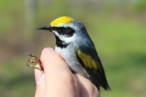
The golden-winged warbler has suffered a 66 percent population decline since the 1960s.

“Hear that?” Dr. Jeff Larkin bent his ears to a nearby cluster of trees amid a sea of briars.

“There’s one in there,” Larkin said excitedly. We were on the trail of a golden-winged warbler, a black-bibbed songbird, which winters in South and Central America and spends its springs and summers here in Appalachia where it breeds, nests and raises its young.

Larkin, professor of wildlife ecology and conservation at Indiana University of Pennsylvania and forest bird habitat coordinator for American Bird Conservancy, has tracked golden-winged warblers for years. And like many others, he has witnessed the bird’s population peril. The bird depends on the cover of early successional habitat to hide its ground nests. Early successional habitat, or young forests, have disappeared across the landscape as forests mature, timber harvest practices change, and disturbance events like fire are suppressed.

Dr. Jeff Larkin, Indiana University of Pennsylvania professor, checking this chestnut-side warbler

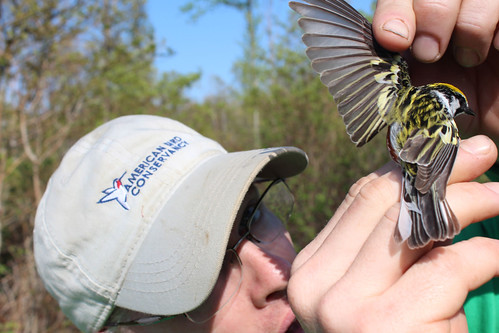
Dr. Jeff Larkin, Indiana University of Pennsylvania professor, checks this chestnut-side warbler for wing mites. Location: Centre County, PA. Credit: Justin Fritscher, NRCS.

Signs of Progress

But this day – here in the woods of Centre County, Pennsylvania – was a day of hope. Larkin and his team witnessed several females building nests on lands managed for early successional habitat.

“We’ve found that when the habitat is managed correctly, you’ll can attract high densities of nesting golden-winged warblers,” he said. The bird likes young forest habitat interspersed among large tracts of contiguous forest with variable age classes. This is important because when young leave the nest, they can transition to using a mix of older forests prior to migration.

Larkin and his partners are working with public land managers and with USDA’s Natural Resources Conservation Service (NRCS) and landowners to create high-quality golden-winged warbler nesting habitat using sustainable forestry practices.

“More than 80 percent of the bird’s nesting habitat in the Appalachians is on privately owned forests, which means the land management decisions by individual landowners is critical to the bird’s success,” he said.

Help for Private Landowners

NRCS provides landowners with technical and financial assistance to help them carry out sustainable forestry practices. Larkin and his team provide the scientific backbone to guide the development of conservation guidelines and to evaluate the bird’s response to conservation efforts. This past summer, his team has been out in the woods conducting bird surveys, banding adults, locating and monitoring nests, and capturing and banding fledglings.

Indiana University of Pennsylvania students

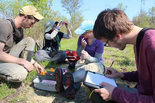
Indiana University of Pennsylvania students trap, band and release birds to help study their response to conservation activities. Location: Centre County, PA. Credit: Justin Fritscher, NRCS.

This year, they caught and released an adult male that that was originally banded in 2011. “That’s a long-lived bird, and it’s exciting to see them return to this habitat year after year,” he said.

The golden-winged warbler is a target species of Working Lands for Wildlife (WLFW) partnership. Since 2012, NRCS has worked with landowners and conservation partners to establish more than 13,000 acres of nesting habitat for the species.

Science Shows Sustainable Forestry Works

This field work by Larkin and his team shows that these conservation efforts are helping the species. They have found that more golden-winged warblers use habitat when early successional forests are clumped close to each other, and when some large trees are left scattered across a timber harvest.

Clumps of trees golden-winged warbler habitat

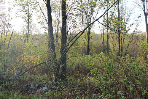
Clumps of trees among early successional forests provide optimal habitat for the golden-winged warbler. Credit: Justin Fritscher, NRCS.

Additionally, lands managed with sustainable forestry practices are home to an average of three golden-winged warbler territories for every 50 acres, and those sites provide habitat for more than 120 bird species – a third of which are suffering from significant population declines.

For example, Larkin’s team is finding that conservation work for golden-winged warbler greatly benefits the American woodcock, a popular game species that conducts its sky-dancing courtship as well as nests, raises brood and forage in young forests. Monitoring on private land sites enrolled in NRCS programs that target golden-winged warbler nesting habitat are revealing that nesting woodcock occupy 40 percent to 80 percent of the sites surveyed. Larkin and his research team predict these numbers will increase as the habitat to develop into a structurally diverse young forest.

Renae Poole banding a bird

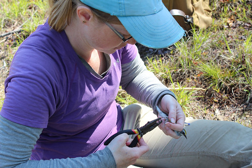
Renae Poole, who works with landowners to use NRCS conservation efforts to help the golden-winged warbler, bands a bird. Location: Centre County, PA. Credit: Justin Fritscher, NRCS.

More Information

Download a new NRCS report by Larkin and other scientists: Sustainably Managing Forests Creates Golden-winged Warbler Breeding Habitat. For more information on how wildlife are thriving on private lands, check out NRCS’ new magazine, Working Lands for Wildlife: A Partnership for Conservation Landscapes, Communities & Wildlife. Landowners interested in assistance to implement sustainable forestry practices should contact their local USDA service center.

Justin Fritscher, NRCS public affairs specialist, with a newly banded golden-winged warbler

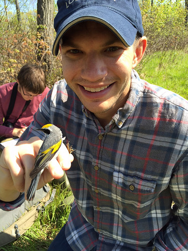
Justin Fritscher, NRCS public affairs specialist, with a newly banded golden-winged warbler.

Digital Plant Diagnosis: Turning a Mobile App into an Agricultural Game-Changer

High quality images of plants

High quality images of plants are the foundation of PlantVillage’s plant disease diagnosis algorithm. (iStock image)

Ireland lost about 20 percent of its population to starvation and emigration during the great famine of 1845-1849 because disease destroyed that nation’s major food source – potato.  Today, an Irish-born professor at Penn State University believes that a similar situation in other regions, such as sub-Saharan Africa, could be a thousand times worse.

But there’s hope, he said, because modern food producers have a tool the 19th century Irish did not – smartphones and mobile apps, like PlantVillage.

According to PlantVillage co-creator Dr. David Hughes, assistant professor of entomology and biology at Penn State’s College of Agricultural Sciences, PlantVillage provides access to a computerized plant diagnostic system that boasts an algorithm capable of diagnosing 26 diseases in 14 crops with 99 percent accuracy.  In essence, computers have been “taught” to diagnose plant diseases by comparing the images of healthy and diseased leaves.

Hughes developed PlantVillage with Dr. Marcel Salathé, former assistant professor of biology in Penn State’s Department of Biology (and now at Switzerland’s Ecole polytechnique federale de Luasanne), to help reduce food loss by making it easier for knowledge providers to share critical information to growers around the world.  According to Hughes, as much as 40 percent of the world’s potential food supply is destroyed by diseases that affect crop plants.

More 2.5 million growers around the world have used the social media PlantVillage platform to ask questions and post images about their particular issues and also to help answer the questions of others.  Many forum answers and images come from experienced growers, extension experts, land-grant scientists, industry professionals, and scientists at international centers.  So far, the expanding A-Z library of plants in the PlantVillage data base ranges from African eggplant to yams.

According to Hughes, the smart phone-based diagnosis is only possible because of plant pathology research funded by USDA’s National Institute of Food and Agriculture (NIFA) and other national bodies around the world, such as the Consultative Group on International Agricultural Research (CGIAR) centers.  The web-based PlantVillage algorithm uses a dataset of more than 54,300 images to make its diagnoses.

The proliferation of smartphones and the acceleration of computer technology is what makes Hughes confident that PlantVillage is a game-changer for agriculture.  It will not replace experts in the field diagnosing plant diseases, but could act as an important tool in areas where land-grant university extension programs are not available.

Game-changing and cutting edge as it is, Hughes sees PlantVillage as just the beginning.  He and Salathé are continuing to expand the dataset of images and improve the algorithm by reaching out to plant scientists around the world.

By merging “crowdsourced” science-based expertise with easy access to information, PlantVillage leverages the very latest in computer science to help tackle crop disease, feed the world’s growing population, and prevent future tragedies like the Irish Potato Famine.

NIFA invests in and advances agricultural research, education and extension and seeks to make transformative discoveries that solve societal challenges.

Simple, Inexpensive Camera System Detects Foodborne Toxins

A system used to detect active Shiga toxin

USDA-ARS scientists developed this low-cost yet effective system to detect active Shiga toxin. USDA-ARS photo by Reuven Rasooly.

This post is part of the Science Tuesday feature series on the USDA blog. Check back each week as we showcase stories and news from USDA’s rich science and research portfolio.

As the weather heats up this summer, many of us are firing up our grills and going on picnics. But one thing we all want to avoid is getting food poisoning from the food or beverages we consume.

Each year, an estimated 48 million Americans get sick, 128,000 are hospitalized and 3,000 die of foodborne diseases. An obstacle to extensive testing of foods for microbes, pathogens and toxins that cause food poisoning is equipment cost, according to an Agricultural Research Service (ARS) scientist.

Reuven Rasooly, a chemist at ARS’s Western Regional Research Center in Albany, California, has developed a simple and inexpensive system for detecting Shiga toxin, a product of pathogenic Escherichia coli O157:H7. This particular pathogen causes about 73,000 cases of food poisoning and more than 60 deaths in the United States each year.

The new system uses a camera and a light-emitting source to detect active toxins. Tests used today cannot distinguish between the active and inactive form of Shiga toxin, Rasooly says. It’s important to tell the difference between the two, because the toxin’s active form poses a threat to humans while the inactive form does not.

“We need devices that are affordable and sensitive to reduce the sources and incidence of foodborne illness,” Rasooly says. “Equipment such as a commercial fluorometer, typically used to detect Shiga toxin and other pathogens, is too expensive for developing countries, where the risk of foodborne illness and outbreaks is greatest.”

In a study, Rasooly and his colleagues showed that the camera system was as effective in measuring Shiga toxin activity as a fluorometer. Both instruments had the same toxin detection levels. The difference is that a fluorometer costs about $35,000 while the camera only costs $300, making it an affordable alternative for diagnostic labs.

In addition, the new system can easily be adapted for detecting other foodborne toxins. Rasooly recently demonstrated that the camera system can be used to detect Aflatoxin B1, a toxin produced by Aspergillus flavus and Aspergillus parasiticus.

“The toxin contaminates crops and foodstuffs worldwide, affecting 4.5 billion people,” Rasooly says.

For an interactive look at USDA’s work to ensure your food is safe, visit the USDA Results project on Medium.com and read Chapter Seven: Safer Food and Greater Consumer Confidence.

5 Must-See Locations in National Forests

By Lindsay Seventko, Communications Intern

National Forests are often synonymous with a long walk in the woods under canopied skies, but here’s a collection of five must see locations in our forests that offer much more than their thick trees or dense foliage alone. From a cliff-top lookout to a giant glacier waterfall and herds of wild bighorn sheep, these exciting destinations are sure to keep you entertained.

1. Round Island Lighthouse, Hiawatha National Forest, Michigan

Connecting Lake Michigan and Lake Huron are the treacherous Straights of Mackinac, full of rocky shoals and shallows that tore apart many ships in centuries past. In 1895, Round Island Lighthouse was built to help warn of these dangerous areas. Long since decommissioned, the lighthouse has been added to Hiawatha National Forest and restored into a breathtaking historical landmark on the tip of a protected wilderness island.

Round Island Lighthouse

Credit: Mark via Flickr.

2. Nugget Falls, Tongass National Forest, Alaska

Nugget Falls rushes out of the melting Mendenhall glacier and into the mountain-framed lake below. This area of Tongass National Forest is home to dense forest which has aged more than 200 years, but the forest also welcomes new life. The melting and moving glacier has revealed new land that has only been without ice in the last 50 years. The result is beautiful young-growth — patches of lush moss and colorful lichens, tiny fungi and sapling spruce.

Nugget Falls

Credit: Trent Roche via Flickr.

3. Sheep Mountain, Angeles National Forest, California

When people think of Southern California, lush forests and abounding wildlife don’t typically come to mind. But, with Sheep Mountain Wilderness in Angeles National Forest, breathtaking vistas and unique animals are the norm. Many hikers on the Pacific Crest Trail cite this section as their favorite, and it’s easy to see why. Home to peaks of more than 10,000 feet in elevation, the wilderness is a wildlife corridor home to three large groups of bighorn sheep that roam the highlands.

Sheep Mountain Wilderness

Credit: Rennett Stowe via Flickr.

4. High Rock Lookout, Gifford Pinchot National Forest, Washington

You can view both Mt. Rainier and Mt. St. Helens from the shelter of this lookout in Gifford Pinchot National Forest. Teetering on the brink of sheer cliffs that drop 600 feet vertically and then careen further to the valley below, High Rock Lookout is an exhilarating hiker’s resting place. Built in 1930, pack mules were needed to carry the necessary timber up the precarious ridgeline. While no longer in official use, the lookout is still the perfect destination for sheltered snacking while looking thousands of miles in all directions, over jagged mountain peaks and gem blue lakes.

High Rock Lookout

Credit: Nick Cramer via Flickr.

5. Red Rock Ranger District, Coconino National Forest, Arizona

Countless photographers have been unjustly accused of photoshopping the rich colors and dramatic contrasts of the Red Rocks Ranger District in Coconino National Forest. Reminiscent of old western movies, this wilderness area is a drastic change from its historic status as wetlands. Now, sharply carved cliffs jut out of Ponderosa pines and rugged desert terrain, their unique geological formations laced in rainbows of red, orange and yellow.

Coconino National Forest

Credit: U.S. Forest Service via Flickr.

What’s Hot in Climate Change, 11 July 2016

Welcome to the inaugural semi, bi-weekly “What’s Hot in Climate Change” post (pun intended!).  The Climate Advisor pours over scores of climate change articles from various media outlets and reputable scientific sources almost daily, so it seemed that besides just twittering out these articles, it might be helpful if we directed readers to the best of the bunch from the past week or two. So this will be a regular update of what this blog thinks are the best stories from the previous few weeks.  There may also be occasional book reviews and other fun and/or interesting stuff.  We will Continue reading What’s Hot in Climate Change, 11 July 2016

The post What’s Hot in Climate Change, 11 July 2016 appeared first on The Climate Advisor.